活動対象地「ムクル地区」について
About Mukuru Area in Nairobi, Kenya
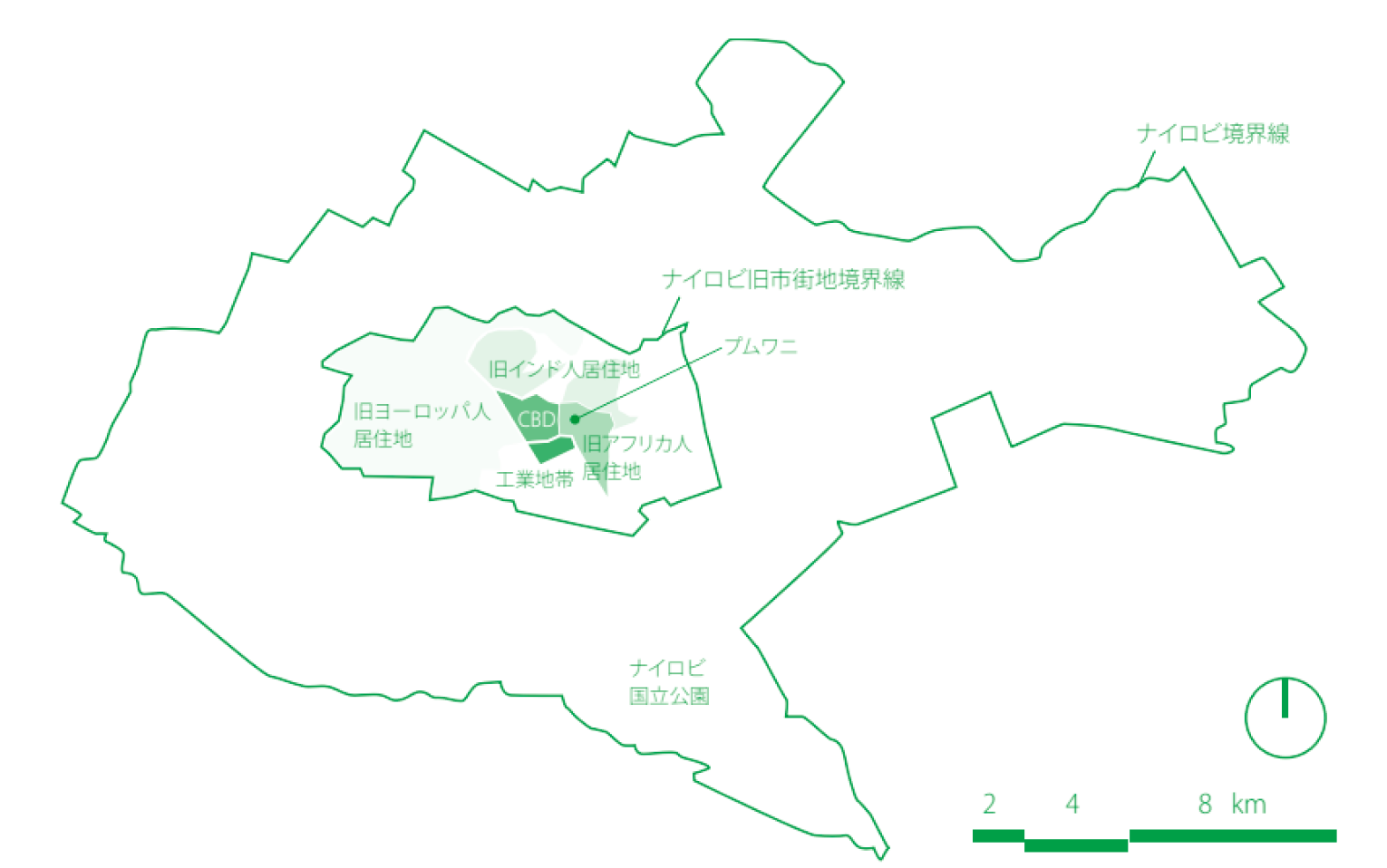
 図1 植民地支配時の居住地区Fig.1 Residential zoning during British colonization
ナイロビの成り立ち / Creation of Nairobi
「ナイロビ」とは、マサイ語で「Enkare Nyorobi (清涼な水)」を意味するように、元々はマサイの遊牧民がウシと山羊を群れを追ってナイロビ川の清涼な水を求めてやってくるような土地であった。ナイロビという「都市」が誕生するのは、イギリスによる植民地支配によってである。イギリスは、1895年に東アフリカ保護領を設立した後、ウガンダを開発するためにインド洋港モンバサからビクトリア湖畔のキスムまでのウガンダ鉄道の建設を開始した。1899年に鉄道がナイロビに到達すると、ウガンダ鉄道の本部がモンバサからマチャコスへ、そしてナイロビに移された。当時の居住者の多くはイギリス人、鉄道建設のためにインドから連れてこられたインド人で、アフリカ人は正規の住人として認められていなかった。その後、1902年にイギリスは、標高の高いエリアは農業に適し、生活しやすいことに気が付き、その一体を「ホワイト・ハイランド」と名付けた。ホワイト・ハイランドを国王の土地と宣言し(「王地条例」)、ヨーロッパ人の入植者に 99年間の期限1) で貸し付けたことで、多くの入植者がナイロビにやってきた。
Nairobi is named after the Maasai phrase Enkare Nyorobi, meaning cool water. Originally, it was where Maasai nomads went with cattles and goats to seek for cool water from the Nairobi river. The City of Nairobi was born under British colonization. After the East Africa Protectorate was established in 1895, construction of the Uganda Railway started. To develop Uganda, the railway connected from Mombasa, the port on the Indian Ocean, to Kisumu, the lakeside of Lake Victoria. When the railway reached Nairobi, the headquarter of the Uganda Railway was transferred from Mombasa to Machakos, then to Nairobi. Residents at that time were British people, as well as Indian people who brought to Africa as labor for railway construction. African people were not recognized as official residents. British people noticed that the high altitude area is suitable for agriculture and easy to live in, and named the area White Highlands in 1902. By The Crown Lands Ordinance of 1902, the White Highlands was declared as land of the King, which granted land to European settlers for the term of 99 years.1) As a result, many settlers came to Nairobi.
その後1907年にナイロビはケニアの首都となった。ヨーロッパ人の数が増加するにつれ、彼らのもとで働くアフリカ人の数も増加していった。ナイロビは中心業務地区(Central Business District:CBD)、ヨーロッパ人居住地区、アジア人(インド人)居住地区、アフリカ人居住地区と明確な居住エリアが定められていき、現在は人種別の居住エリア構成は存在しないものの、所得層に引き継がれる形で当時の居住エリアが色濃く反映されている (図1)。つまり元ヨーロッパ人居住地区は現在の高級居住地区として引き継がれ、多くの外国人が居住している他、元アジア人居住地区には現在も多くのインド人が、そして元アフリカ人居住地区は現在は低所得者層居住地区となっている。当時、ナイロビ内においてアフリカ人が居住することのできる「原住民居住区」は、イーストランド地区のプムワニに限られていた2)。
In 1907, Nairobi became the capital of Kenya. As its European population increased, its African population working under Europeans also increased. Nairobi was divided into different residential zones, such as the Central Business District (CBD), the European zone, the Asian (Indian) zone, and the African zone. The racial zoning of the residential area does not exist anymore, but the same boundary often remains between zones for different income levels (Fig.1). The former European residential zone turned out to be the current high-income residential zone, residence of many international citizens. A lot of Indian people still live in the former Asian residential zone, and the former African residential zone is the low-income residential zone now. During the colonization, African people could live in the indigenous settlement, which was only at Pumwani of the Eastland district. 2)
また、16歳以上のアフリカ人男子は登録された「原住民居住区」を離れるときにはキパンデと呼ばれるカードを携帯しなければならなかった3)。しかしながら、アフリカ人をプムワニ内にのみ居住させる政府による計画は上手くいかず、1930~40年代にかけてイーストランド地区のなかにパンガニを始めとしたいくつものアフリカ人によるアフリカ人出稼ぎ民のための町が誕生していった。そうした流れを受け、政府もアフリカ人向けの公共住宅建設を開始し、シャウリモヨなどの住宅地が形成されていった。一方、1963年にイギリス植民地支配より独立を果たした後、移動の制限の無くなったアフリカ人による農村部からナイロビへの大量の人口流入が起こった。急激な人口増加の中、低所得者層の出稼ぎ民が賃貸できる住宅は整備されず、彼らの多くはナイロビ内のスラムに居住するようになり、多くのスラムが形成されていった。
When African male under the age of 16 left the indigenous settlement, they had to carry a card called Kipande.3) However, the government’s plan to force all Africans to live at Pumwani failed. In the 1930s and 40s, many towns for African migrant workers were organized by African people inside the Eastland district, including Pumwani. Due to the situation, the government started construction of public housing for African people, and residential areas such as Shauri Moyo emerged. In 1963, Kenya became independent from British colonial rule, and restrictions on transportation were lifted, which resulted in massive inflow of African population from rural areas to Nairobi. Despite the acute increase of population, affordable rental housing was not developed for low-income migrant workers. As a result, a lot of migrant workers started living in a slum in Nairobi, and many slums had surfaced.
-
1)1915年に改定され1999年に変更された。The permission was revised in 1915, and its terms were changed to 999 years.
-
2)松田素二:都市を飼いならす、河出書房新社、1996、pp.86Motoji Matsuda, Toshi wo Kainarasu (in Japanese), Kawade Shobo Shinsha, 1996, pp.86
-
3)宮本正興+松田素二:新書アフリカ史、講談社現代新書、1997、pp.314Masaoki Miyamoto + Motoji Matsuda, Shinsho Afurika Shi (in Japanese), Kodansha Gendai Shinsho, 1997, pp.314
ナイロビ市内のスラムの概要 / Overview of slums in Nairobi City
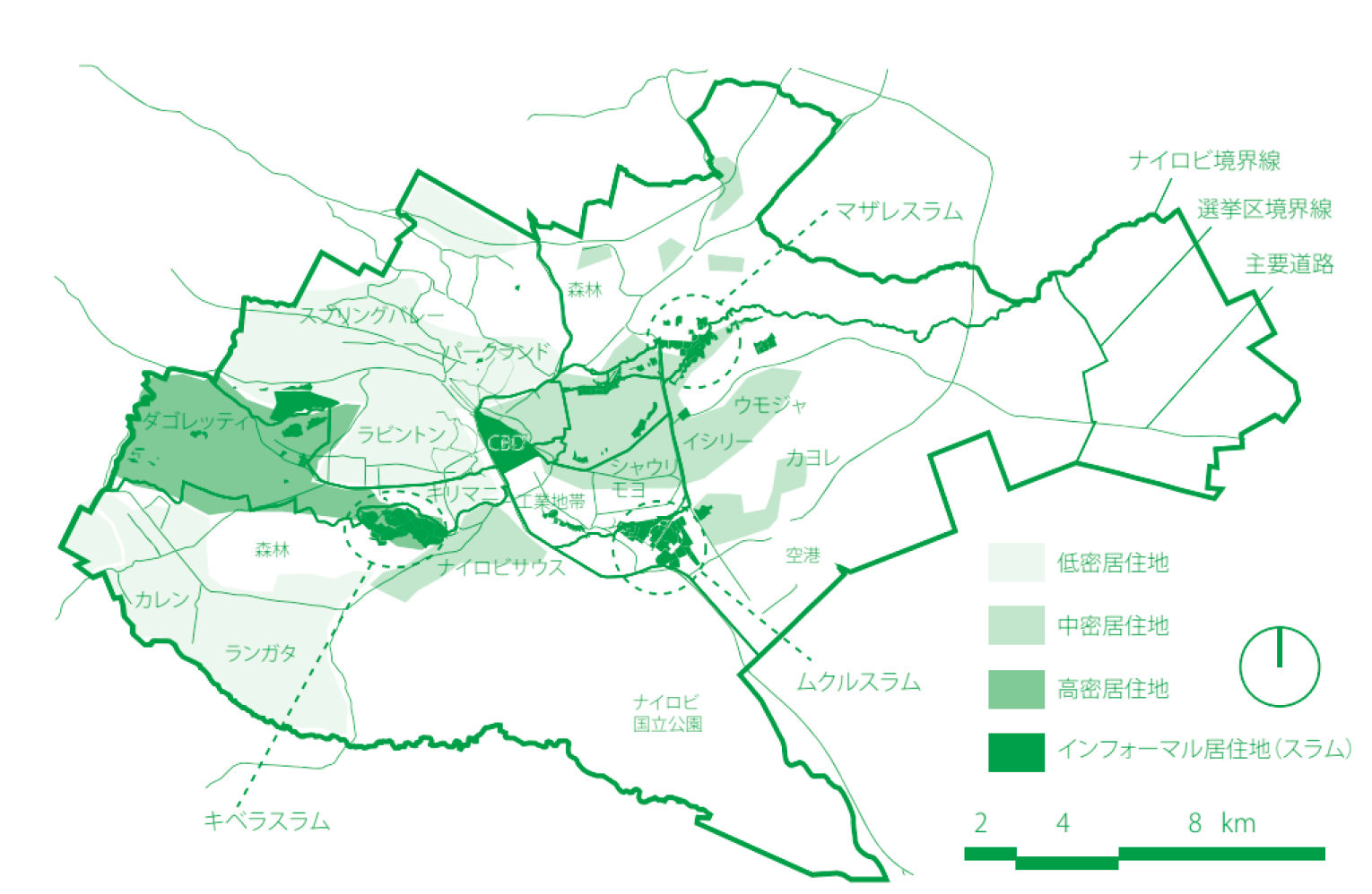
「現在、ナイロビには 100 を超えるスラムが存在すると言われ、その中にはナイロビで最も古いマザレスラムや最も巨大なキベラスラムが含まれる。一般にナイロビの スラムはインフォーマル居住地であり、農村部からの大量の出稼ぎ民によって形成される低所得者層向けの高密居住地である。これらは、「原住民居住区」の規制の無くなった1963年の独立以降に急速に拡大し、一般に旧市街地境界線のフリンジに位置している(図2)。また、元々未利用地であった川沿いや低湿地、鉄道沿い、石油パイプライン沿いなど、リスクの高いエリアに立地している他、工業地帯などの職場まで徒歩で通うことのできる距離4)に形成される特徴を持つ。
Reportedly, there are more than 100 slums in Nairobi now, including the oldest Mathare slum and the largest Kibera slum. In general, slums in Nairobi are informal settlements and very densely populated with low-income people. After the independence of Kenya in 1963, the restriction on the indigenous settlement was lifted, and slums expanded quickly. These slums are usually located around the edge of the former urban area. (Fig.2) Their locations are often lands of higher risk, such as unused riverside land, wet lowland, and land along a train track or an oil pipeline, and in a walking distance from workplace of residents, such as an industrial area.4)
 図2 インフォーマル居住地の分布Fig.2 Distribution of informal settlements
インフォーマル居住地は、スクウォッター(不法占拠)タイプと、私有地を違法に再分配するタイプの2種類に分けることができる。スクウォッタータイプが元々支配的であったが、近年のインフォーマル居住地の多くは、法律上の土地の所有者が存在しながらインフォーマルなシステムによって土地の再分配が行われる後者のタイプが一般的になっている5)。そのため、法律上の所有者が権利を主張し、土地の開発のためにスラムが撤去される事例も相次いでいる。
Informal settlements can be categorized into two: squatter (illegal occupation) type and illegal redistribution type. Originally, the majority was the squatter type, but the latter type is more common among recent informal settlements. These slums are on land with a legal owner, but the land is redistributed through an informal system.5) Therefore, in some cases, a legal owner claims its right on land for development, and a slum on the land is removed because of that.
-
4)スラム居住者の多くは公共交通は利用せず、徒歩で近隣の工業地帯や、職の需要のあるエリアにまで通っている。Most slum dwellers do not use public transportation, but walk to a nearby industrial area or a place with job opportunities.
-
5)Matrix Development Consultants : Nairobi's Informal Settlements - An Inventory, USAID, 1993
ムクル地区について / About Mukuru Area
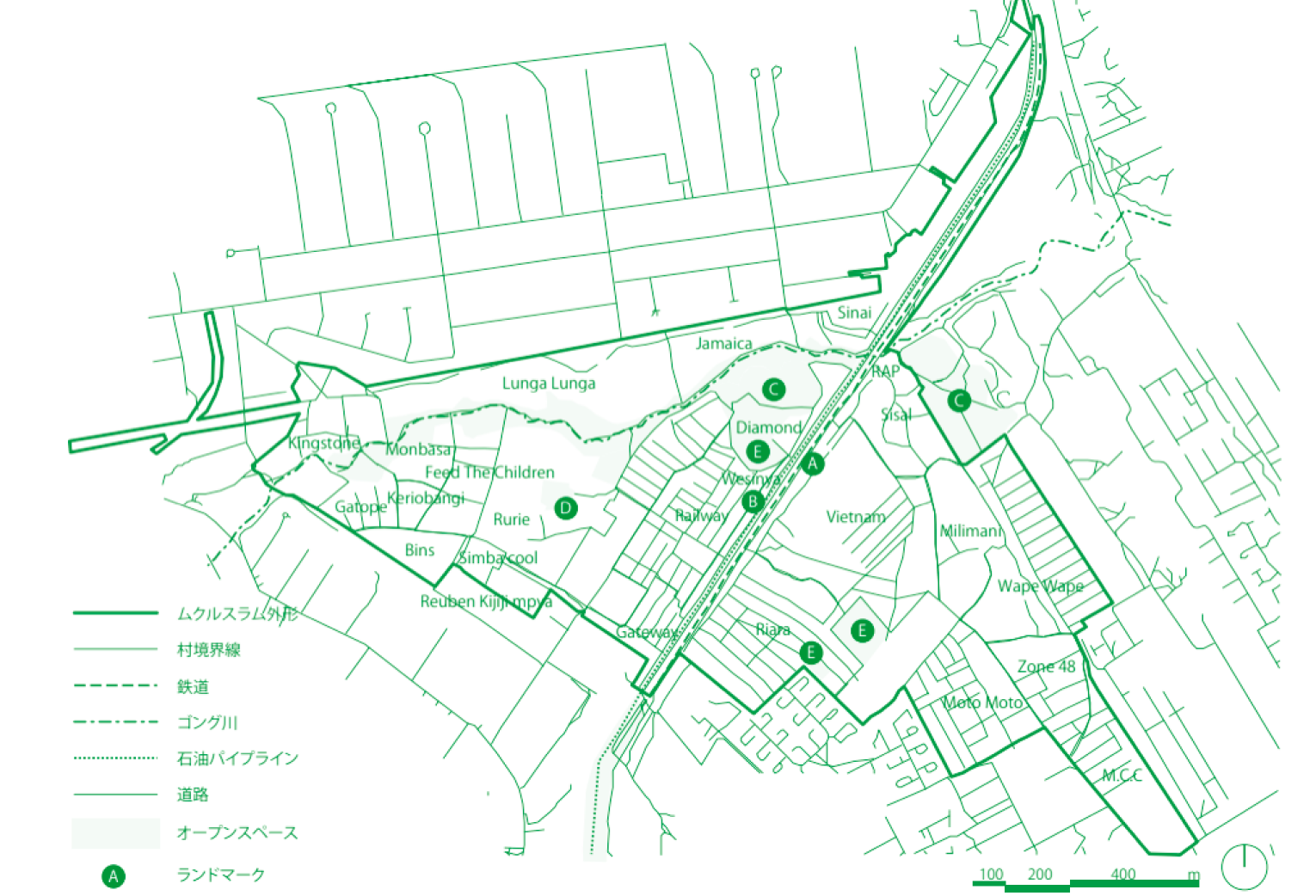
ムクル地区は、ナイロビ市内のスラムのひとつで、1979年に発祥したとされる。ナイロビ東部の工業地域内に位置しており、 居住が一般に認められていないインフォーマル居住地である。ムクル地区は約 5㎢の面積を持ち、ここに約70,000人が居住していると言われている6)。ムクル地区は、ムクル・クワ・ルーベン(Mukuru Kwa Reuben)、ムクル・クワ・ジェンガ (Mukuru Kwa Njenga)、ルンガルンガ(Lunga Lunga)の3つのエリアで構成される。また、こうしたエリアはさらに小さな村 (Village) に分けられ、合計27の村によって構成されている。ムクル地区には鉄道(Kenya Railway)、石油パイプ(Kenya PipeLine) が北東部から南西部に平行して走っている他、スラム北部をゴング川(Ngong River) が横断している。
このゴング川より北がルンガルンガ、川と鉄道の間がムクル・クワ・ルーベン、鉄道より南が ムクル・クワ・ジェンガとなる。
Mukuru Area is one of the slums in Nairobi, formed in 1979. It is an informal settlement, where dwelling is not allowed, inside the industrial area in the east of Nairobi. About 70 thousand people live in the area of about 5 square kilometers.6) Mukuru Area consists of three smaller districts: Mukuru Kwa Reuben, Mukuru Kwa Njenga, and Lunga Lunga. These districts are further divided into 27 smaller villages. Kenya Railway and Kenya PipeLine run through Mukuru Area from the north east to the south west. The Ngong River goes across the northern part of the slum. The north of the Ngong River is Lunga Lunga, the district between the Ngong River and the Kenya Railway is Mukuru Kwa Reuben, and the south of the Kenya Railway is Mukuru Kwa Njenga.
 図3 ムクル地区の地図Fig.3 Map of Mukuru Area